Riding a scooter or motorcycle all the way around Taiwan is an awesome adventure and a life goal for many intrepid Taiwanese and resident expats. I know it seems like a daunting task, but it’s really not that hard, even if you don’t speak any Mandarin. I’ve done it many times, and I’ll try to give you tips and advice on how to do it yourself.
A little about me: I’ve lived in Taiwan for 15 years now and have probably ridden around the island 15-20 times, with an uncountable number of day rides around Taipei. I used to do it on my old 125cc SYM Legend (it’s a small motorcycle), but now I do it on my 321cc Yamaha R3. I’m also a mountain guide and co-own the company Taiwan Adventures, so I’m out there all the time.

I think this was my second huandao in 2008. Alishan Road, near Tatajia.
History of the Huandao
The word huandao 環島 (huándǎo) in Mandarin means “around island”. A huandao can be done on a scooter, motorcycle, bicycle, or even a car, but I’m going to mostly talk about doing it on a scooter or motorcycle.
While people have been doing this for many years, going on a huandao became really popular amongst Taiwanese youth after a 2006 Taiwanese movie called Island Etude (Trailer, great article from Taiwan in Cycles).
Nowadays, it’s a right of passage for young Taiwanese to go around the island on a scooter or bicycle to learn about their Taiwanese identity. If you do one, or find yourself traveling on the east coast for any reason, you’ll probably see people driving around with “環島中” or “環島ing” written on their backs or scooters. This means “I’m in the middle of driving around the island”. There’s even a market for stickers, signs, and such on Shopee.

Preparing for a Huandao
It’s super easy:
- Get a reliable scooter or motorcycle.
- Pack a backpack with clothes.
- Go.
That’s really all there is to it. With a smartphone and internet access, you can figure everything else out on the road.
- Don’t know which route to take? Google Maps (Set it to motorcycle mode)
- Don’t know where to sleep? Agoda or Booking.com.
- Don’t know where to eat? 7-11.
- Need gas? Google Maps. A good rule for getting gas is to always fill up if you’re passing a gas station and your tank is down to 1/4. If you’re in the mountains, fill up if you pass one and the tank is 1/2 full.
Seriously, you could be on the road doing your own huandao 5 minutes from now. There’s nothing to be scared of. Yes, you’re going to get lost (even with Google Maps); Yes, you’re probably going to be nervous about lots of things as you travel, but Taiwan is an incredibly safe place to be, and the locals are very friendly, especially when you’re out in remote places like you will be on this trip.
Actually Preparing for a Huandao
I think that part of the fun of going on a trip like this is the preparation. So here’s a comprehensive list of things you might want to take with you. Please note that you certainly don’t need all of this, it really depends on you and what your plans are.
The absolute most important thing to me is the weather. I’m lucky enough to have an odd work schedule that gives me many weekdays off and I can often wait for a good forecast. If you’re not as lucky as me, driving in the rain isn’t too bad, so don’t cancel unless there’s a typhoon warning or something. Give yourself an extra day in your itinerary in case there’s a day with really heavy rain. Otherwise, you’ll probably only be driving for 3-4 hours each day, and that’s not so bad in the rain.
Research and Planning
First you need to decide how long your huandao will be. If it’s your first time, anywhere from 7-14 days is pretty good to visit the major sights. If you want to ride for about 8 hours a day, you can do it in 3 days, 2 nights. There is a “24 Hour Challenge” that involves circumnavigating the island in a single go, but I wouldn’t recommend that for most.
You should spend A LOT of time researching where you want to go. Or, if you’re like me, spend a lot of time looking for roads that you want to drive on! :) Either way, get real comfortable using Google Maps and learn how to save locations. Then when you’re on the road, you can quickly bring them up and use GPS to find them.
Google Maps is so good, I can’t even think of a word to describe it. I spend hours and hours pouring over it. I search for words like “campground”, “viewpoint” and “waterfall” that all give good results, even in English. I then look at reviews, pictures that people have uploaded, and look at Street View to see what the road surfaces are like. 90% of your research time should probably be on Google Maps.
To find hotels, hostels, or B&Bs, just use the Agoda or Booking.com apps. I’ll often just book a hotel in the morning or afternoon of the night I want to stay there, that way I can keep a very flexible itinerary.
The Most Important Things
- A Reliable Motorcycle or Scooter – Luckily these are readily available in Taiwan for cheap. Check the tires and change the oil before you leave. Check the air pressure in the tires every morning. If you have any problems on the road, every village has several mechanics and they’ll be able to fix anything for cheap. A 125cc is fine and what you’ll see most Taiwanese riding.
- A GOOD Helmet – There’s nothing more important than this. Get the most expensive one you can afford. Seriously. It might literally save your life or keep you from being a vegetable for the rest of it. You can get ones that are “good enough” from the Taiwanese helmet shops, but be sure to spend at lease $1,500TWD on one. It’d be even better to spend $3,000+. If you’re headed out on a heavy motorcycle, you should have one that costs at least $6,000TWD. Please note: It’s really hard for me to give you a suggestion for a helmet on a simple list like this. If you have any questions, please leave a comment below.
- Rain Gear – Buy good, heavy duty rain gear from one of the helmet shops in any city in Taiwan. Don’t leave with a cheap, disposable rain jacket from 7-11. Your rain gear doubles as a wind proof layer and gives you extra warmth if you need it.
- Warm Clothes – Yes, it might be summertime and 36ºC in your city right now, but it’s cooler on the east coast and downright cold if you’re going to cross the mountains (even in the summer). I always take one heavier layer of clothing and I always end up wearing it. (And often wish I had more!) Also, bring a windproof jacket in addition to the rain gear.
- Dry Bags – You can find cheap dry bags in any hiking store. Get a few because they’re great to organize your stuff and will keep everything perfectly dry.
- Bungee Cords – Essential to strap everything to your bike. Bring a few extra because they break and get lost easily.

All packed up at the Tsengwen Reservoir on the western Route 3.
Other Gear Considerations
- Saddlebags – If you’re going to be camping, you’ll probably need these to fit everything on your bike. Otherwise, you should be able to strap everything to your back seat with bungee cords.
- A Phone Mount and USB Port – These are damn near essential. You’ll probably be using GPS to help guide your way and you’ll need a phone mount to see it and a USB port to keep your phone charged. I have two USB ports: one for the phone and one to charge other stuff like camera batteries.
- A Swimsuit – There are lots of nice rivers, hot springs, and oceans around to swim in.
- Clothing – Take less than you think you need!!! You’ll never need more than 3 complete changes of clothes, and I rarely take more than two. Don’t forget the warm clothes and rain gear I previously mentioned.
- Personal Items – Sunglasses, sunscreen, a toothbrush, toilet paper, bla bla bla. Bonus item: I keep a handkerchief in my pocket for a million uses.
- Scooter Safety Clothing – If you’re on a scooter or small motorcycle and driving relatively slowly and safely, you probably don’t need any special safety gear. That said, remember that you can fall off your scooter at any time, so wear clothing that might save you some pain if you slide across the pavement. For instance: Wear hiking boots or leather sneakers, don’t wear flip-flops! (unless you want to lose some toes); Wear jeans, not shorts (unless you want sun burnt knees); Wear a medium-weight jacket or at least a long sleeve shirt. I’d also recommend gloves to protect your hands from the sun.
- Motorcycle Safety Clothing – If you spent $300,000+ on a motorcycle and I have to tell you that you need to wear proper safety gear on a huandao… just stay home.
- Camera Gear – I’m a photographer, so I usually have a camera, two lenses, a tripod, a GoPro, and often a drone with me.
Camping Gear
I always camp for at least a few nights on my huandaos. You don’t have to, but to me it’s an essential part of the experience. Usually I’ll split my nights wild-camping, camping at a campground, and sometimes staying in a hotel. It just depends on how I feel that day.
- Tent – I use a 2 person tent that can free stand (ie: it doesn’t need to be staked into the ground to set up). I sleep on one side and all my gear is on the other side. I know some people that use those high-end camping hammocks, but it’s just not my thing.
- Sleeping Mat – Oh, hell yeah.
- Sleeping Bag – I usually use a 0ºC bag. The only time I don’t is if I know I’m going to be staying at low elevation in the summer. In the mountains, it can easily go down to 0ºC at night, even in the summer. Being warm is nice.
- Cooking Equipment – Lately, I’ve been taking a camping stove and gas so I can make coffee and oatmeal in the mornings when I’m camping. I used to just pack up camp and go to 7-11 for coffee and breakfast, but taking my time in the morning is so much nicer.
- Camping Chair – This is super posh, but I often wild-camp in remote parking lots and such, so it’s SOOO nice to have a comfortable chair to relax in and drink whisky.
Finding Camping Spots
I’ll mix my camping locations between using campgrounds and wild-camping. By wild-camping, I mean camping along the side of the road or on a beach or something.
Campgrounds
If you want to stay at a campground, there are hundreds on Google Maps, but beware that a lot of them are out of business. It’s best to call them ahead of time to be sure they’re open. Try to stay at the bigger, more popular ones. Look for ones that have many reviews on Google Maps. You can also use Taiwan Camping to find campgrounds.
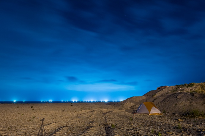
Camping on the beach in Dongao, just south of Yilan. (The lights in the background are fishing boats out to sea)
Wild-Camping
Finding wild-camping locations can always be a bit tricky, but once you do it a few times, it’s not so stressful. This is one of the things I spend a lot of time researching on Google Maps. I’ll get a general idea of where I want to sleep at the end of the day and use Google to find several suitable locations. Often, the first place I researched doesn’t work out for one reason or another, so I’ll drive to the second location. Sometimes, all my planned locations are unsuitable but I always find a place that works out. It’s best to find your spot before it gets dark.
- Never stay on what looks like private property: fruit farms, fields, business parking lots, etc.
- I don’t ever wild-camp near cities, but you probably could if you find a seclusive spot.
- You can always stay on the beach, but be careful that there’s not an unusually high tide that night. (This happened to me once because there was a typhoon way off the coast that made the tide 1.5 meters higher than usual!)
- I’ll often stay at lookouts with pagodas or at the start of a hiking trail.
- Be quiet at night and pack up and be gone by 7:30ish in the morning.
- Be careful not to camp someplace where there might be activity in the morning like a worksite.
- Sometimes in remote villages, I’ll go into a store and ask about a place to camp. They often say to camp in a nearby parking lot or on the local school’s grounds… it’s no big deal.
- You’re technically not allowed to wild-camp in national parks, but in reality lots of people do it, often under “no camping” signs, and the rangers don’t care. If I’m ever in a national park and want to wild-camp, I’ll do it someplace where no one can see me, behind some trees or over a small hill or something.
- You can usually stay outside police stations and they’ll often give you tea. Ask first. The police in remote areas are usually very helpful.
Follow Xiaofei has a very comprehensive list of waterfalls in Taiwan and he often mentions if he saw a good spot to camp: https://followxiaofei.com/
Taiwanese Attitude Towards Wild-Camping and Safety
Don’t worry about it! NOBODY cares if you’re camping on the side of the road. Especially if you’re in the mountains or on the beach or near remote villages, nobody will even bat an eye at you camping. If they’re looking at you, it’s probably because you’re (probably) non-Asian and they’re just curious, not because you’re camping.
Taiwan is one of the safest countries on Earth, but you still have to be careful. I follow this rule: Either camp where there’s no one around or where there’s lots of people (like at a campground). If you meet other people camping in Taiwan, they’re probably going to be the nicest people you’ve ever met, but it doesn’t hurt to be careful.

Route Planning
Obviously, there are lots of different routes you can take and places you can visit, but here are my suggestions for where to go and how to get there. I’m going to start in Taipei and go clockwise around the island, but obviously you can go the other way or start somewhere else if you want. I’m also going to mostly skip the cities and just tell you about a few “must see” sights along the way. There are many, many more interesting places for you to visit, but that’s something for you to research on your own.
The North (Around Taipei)
I’ll keep this part short because I think most of you aren’t looking for info on this area. It’s pretty simple: If you start in Taipei, you can take Route 2 around the Northeast Coast all the way down to Yilan or take Route 9 south of Taipei to Yilan. Route 9 is the fastest way but both ways are great drives. Be extra careful on Route 9 on weekends. There are a lot of knuckleheads driving faster than they can handle on it.
You can also take the absolutely awesome Route 7 (The Northern Cross Island Highway) but I’ll cover that in the Mountain Roads! section below.

The view of Yilan from Route 9.

2006 with friends at the Baling Bridge on the North Cross Island Highway
The East Coast
This is the whole reason you’re doing a huandao and really the only place you need to go. A lot of people will describe the east coast as being “wild” and “remote”, but there’s nothing to fear. There are little villages everywhere. It also has amazing scenery everywhere and the people and general vibe is always laid back.

Yilan to Hualian
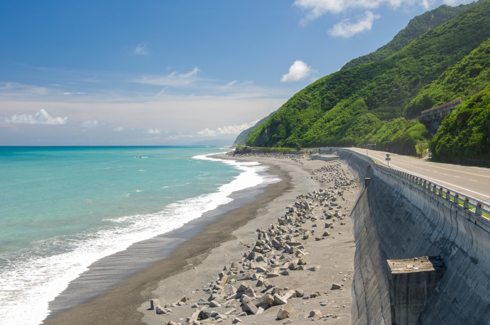
From Yilan, take the famous Suhua Highway (Route 9丁) down to Hualian. This is a stunning stretch of coast worthy of many road side stops to take pictures. Here you’ll find the famous Qinshui Cliffs and some beautiful bays, harbors, and mountains. The best section is from Heping Village to Chongde Village, just north of the entrance to Taroko Gorge.
Take note that the new highway, Route 9 is open only to cars. No scooters or even heavy motorcycles are allowed on it. It gets a little confusing because the new highway mixes with sections of the old Route 9丁, and sometimes it’s not obvious how to stay on 9丁 and not go on the cars only route. Since the new highway opened, I’ve only driven a motorcycle on that route once, so I don’t have a lot of advice how to stay on the proper road except to look for the “cars only” signs like the one below, and then don’t go on that road.
Don’t miss: The view from this temple, This famous beach, This stunning viewpoint, and The Qinshui Cliffs.
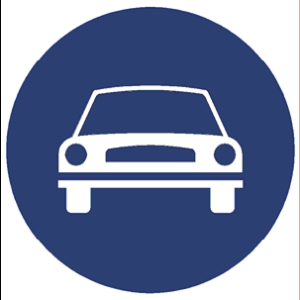
If you see this sign, it means only cars are allowed on that road. It’s usually hung at the start of on-ramps to expressways.

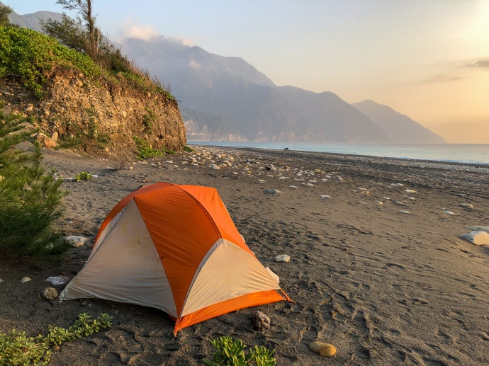
The view of Dongao Bay from the temple on Route 9丁

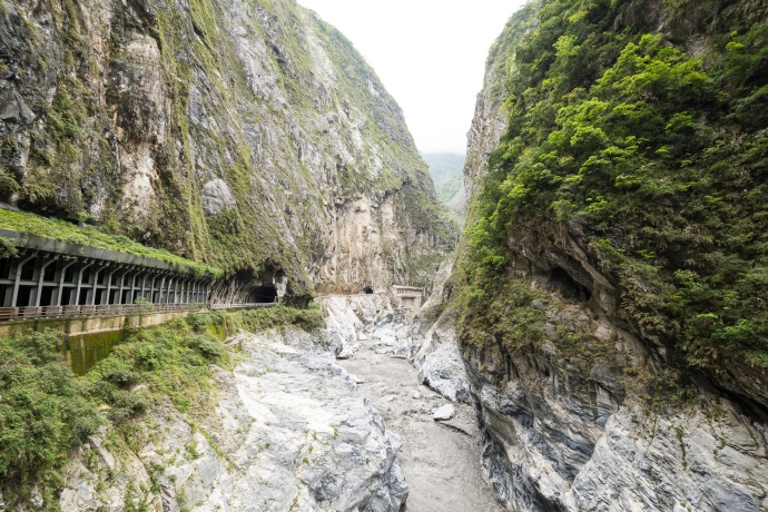
The Qingshui Cliffs. See the road that carves through it? You’ll be driving on that.
Taroko Gorge
You want to go to Taroko Gorge. No exceptions. Spend at least a day hiking the easy tourist trails or take an extra day to hike the famous Zhuilu Trail. Even if you only take a few hours to drive up to Tianxiang Village and then turn around, you’ll be blown away!
Don’t miss: Any of it, especially the Shakadang Trail and the Baiyang Trail.
Yep. That’s the road you’re going to take through Taroko Gorge.
Hualian to Taitung
While not truly considered a huandao, a fantastic trip is to drive the whole east coast and go through the Rift Valley (Route 9) in one direction and stay along the coast (Route 11) going back. There is enough to see and do there for several trips. This is all easy driving.
That said, I like the coast much more than the Rift Valley, but there are definitely people that might disagree with me.
For the coastal route, start in Hualian and stay on Route 11 all the way to Taitung. It’s only a 3 hour drive, but you should take a whole day to explore. Better yet, plan on staying in one of the nice B&Bs that are all along it or stay at the best campground in the world, Shitiping. The Village of Dulan, to the south near Taitung, is a village with a lot of hippy expats, artists, and surfers. Lots of expats love it here, and it’s a good place to stay a night have have a beer and a chat with locals (expats and Taiwanese alike).
Don’t miss: Shitiping, Sanxiantai, the village of Dulan … While I’m not going to list a lot of “must see” locations, every inch of this stretch is “must see”, if you know what I mean. Read my old post on Shitiping Campground.

Highway 11 on Taiwan’s east coast stretches along some beautiful coastline.

A rice farm sits next to the Pacific Ocean on the east coast of Taiwan.

The view of the sunrise from my tent at Shitiping.
Taitung to Kending
This section starts off with a pretty quick rip down the coast on Route 9, followed by an awesomely windy 9戊. Please note that there’s a new highway here, too. Just be careful to stay to the left about 1km after you turn inland from the coast in the village of Daren. I just did this one, and it’s pretty easy to see.
When you get to the top of 9戊, you have the choice to follow the small Route 199 south or continue on the faster 9戊 to the west and then take Route 26 all the way south to Kending. If you have the time, take the 199 to 199甲 to Route 200. I really like those roads. They’re very remote and pass through some nice aboriginal villages and a nice stretch of the east coast. There are lots of wild-camping spots but no gas stations and very few restaurants or stores along this route.
Must See: There are no major points of interest other than Kending, but it’s all really, really good.
Route 11 south of Taitung is a quick drive, but it’s really beautiful!

A mural in an aboriginal village on Route 199甲。
The Western Side of Taiwan
There are basically two routes to take heading back north: You can hug the mountains or stay along the coast. Obviously, you can cut back and forth between these routes if there’s something you want to see, but I’m going to try to keep it simple.
The Coastal Route
The coast itself is boring and there’s very little to see outside of Kaohsiung, Tainan, and Lukang. Some might disagree with me, but there’s definitely much more to see on the Mountain Route and the roads are much more fun to drive.
From Kending, head north on 26, then Route 1 to Route 17. You’re going to have to drive through lots of city traffic around Kaohsiung and Tainan until you get to Route 61.
Route 61 is both a blessing and a curse. If you’re on a motorcycle with a yellow or red plate, you can drive on the finished expressway sections and get to the north relatively quickly. Personally, I hate doing this because I hate driving on those long, boring expressways and there is often a lot of wind on the west coast making it even worse. If you’re on a smaller white plate, you can still more-or-less follow Route 61 and it’s still pretty quick. Google Maps will definitely be your friend if you’re trying to do that.
That’s it. Just follow the 61 all the way back to Taipei.

A temple in Lukang.

The Western Mountain Route
Windy roads, mountains, rivers, waterfalls, aboriginal villages… The Western Mountain Route has it all. Much like the east coast, you could spend days and days and days exploring the nooks and crannies of the this route.
From Kending, head north on 26, then Route 1 to Route 185 and relax as you pass miles and miles of farms. Soon you’ll start passing the aboriginal villages of Sandimen, Wutai, Maolin, and many others. There is lots of great stuff to explore around here.
Continue up on the 185 and take 27 or 27甲 to Route 20. Route 20 to the northeast is called the Southern Cross Island Highway. It is one of Taiwan’s most amazing roads, but has been closed for over 10 years. You can still drive up it to the closed point just past Meishan. It’s good if you have the time. Otherwise, take Route 20 to the west.
Follow Route 20 until you come to Route 3. Route 3 is an amazing road that stretches from here all the way up to Taipei. Most of it is awesome and my favorite section is the one you’re headed for now, the stretch past the Tsengwen Reservoir (Here’s a great free campground). If you plan on going to Alishan, you can take the small back roads from the reservoir called the Qingshan Industrial Road and the Xinmin Industrial Road to Route 18. They are awesomely remote, but a little rough if I remember correctly. You could also stay on Route 3 past the reservoir for more amazing turns. It will lead you to Route 18 that you can take to Alishan, if the Qingshan Industrial Road seemed a little too tough. (I’ll cover the Alishan road in the Mountain Roads! Section)
If you want to keep going north past Route 18, Route 3 gets a little boring. I’ll often take Route 149 from Meishan to Zhushan and then reconnect with Route 3. There’s a lot to explore back on this windy, fairly remote route.
From Zhushan to above Taichung, Route 3 is a bit boring again. This is a good area to cut into the mountains. You’ll definitely want to go to Sun Moon Lake. It’s really beautiful and there are a day or two worth of sights to see there. I’ve been there a million times, so I’ll usually take Route 16 to Route 131 to Route 147 and continue north. There are a lot of nice remote turns to make back there.
From Sun Moon Lake and the Puli area, you can take Route 14 to 14甲 to Taiwan’s highest road at 3,200m in the Hehuanshan Area, then Route 8 east to Taroko Gorge or Route 8 north past Lishan to Route 7甲 to Yilan. I’ll cover those in the Mountain Roads! Section.
If you’re still going north from Sun Moon Lake/Puli, take Route 14 to Route 21 north to Route 8 north. Note that Route 8 to the east is the other mountain road that’s closed just past the hot spring area of Guguan.
The road that leads from just south of Dongshi to the Dashuishan National Forest Recreation Area is a fun drive and there are a few good short hikes and some beautiful things to see, but it is a spur road.
In Dongshi, you can reconnect with Route 3 and follow it all the way back to Taipei. I really like the area through Miaoli County. A good side trip is to take Route 124 to Nanzhuang.
Must See: Tsengwen Reservoir, Sun Moon Lake, and the Alishan Recreational Area, but there are actually too many places to mention.


The Tsengwen Reservoir.

Sun Moon Lake
Mountain Roads!
One of the reasons Taiwan is so good for motorcycling is the fact that it’s very mountainous and has amazing, windy roads throughout those mountains. Being that I own a hiking guide company (shameless plug: Taiwan Adventures), I could go on and on about how good the hiking is here, but I’ll try to stay in the huandao lane.
I think I should start with some concerns about driving in the mountains.
- Some of the roads are closed.
- There are two mountain roads that show up on maps but are permanently closed:
- Route 8, just east of Guguan
- Route 20, from Meishan to the Xiangyang Tourist Information Center.
- There are two mountain roads that show up on maps but are permanently closed:
- Sometimes after typhoons, earthquakes, or heavy rains, rock slides will wash out the roads but they usually reopen fairly quickly.
- Check this website for information on road conditions: https://168.thb.gov.tw/ (Mandarin only)
- It’s colder there.
- The mountain roads in Taiwan go up to 3,200m, that means the temperature might be 20ºC colder there than in the cities.
- Even the roads around Taipei that only go up to 1,000m can be quite a bit colder.
- It can go down to 0ºC at night, and often does, even in the summer.
- There generally aren’t as many gas stations, but it’s not that bad.
- My rule is that if I’m passing a gas station in the mountains and my tank is 1/2 full or lower, I fill up.
- They usually close at 5 or 6pm. Plan accordingly.
- Gas stations on the North Cross Island Highway, going north to south: Fuxing, Datong, near Yilan; Nanshan; Lishan (A particularly good one to note)
- Gas Stations on the Central Cross Island Highway: Guanyuan, at the top of Taroko Gorge; Qingjing; Wushe.
- Gas Stations on the Alishan Road: Zhongheng, near Dongpu hot spring village; Alishan; Shizhuo; Alishan-Xiding.
- When in doubt, just Google Maps search for 加油站, but doing it in English usually works fine, too.
- There also generally aren’t as many places to eat and hotels to sleep in, but you’ll be fine, they’re around.
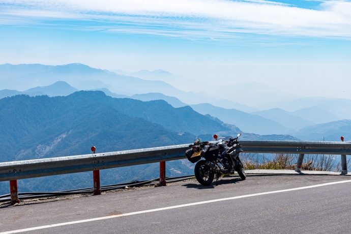
On the Central Cross Island Highway near the highest point of any road in Taiwan.
The North Cross Island Highway
Route 7 AKA The North Cross Island Highway is the shortest of the cross island highways, going from Taoyuan (Fuxing, really) to Yilan. When I think of it I also consider Route 7甲 a part of it, so I’ll include that section in this section.
Route 7 is an amazingly curvy road that cuts through a very remote part of Taiwan. An excellent day trip for anyone living in Taipei is to ride it right around and take Route 9 back. (That’s about 6-8 hours) Fill up your tank at Fuxing, because there’s not much out there other than a few restaurants at Baling.
If you want to spend even more time in the mountains, head southwest towards Lishan on Route 7甲. This road is nice, but not nearly as nice as the other mountain roads. You’ll pass Wuling Farms along the way. It’s a popular weekend get-away for Taiwanese city dwellers and has a great campground, several hotels, the world’s only landlocked salmon species. It’s also the start for some great hikes like Snow Mountain and the Sixiu. Lishan has a gas station, some tourist stuff, and a few restaurants and hotels. There’s a great campground at Fushoushan, but it’s over 2,500m there and gets really cold at night.
From Lishan, Route 8 towards the west and Taichung is closed, so you have to go south towards Dayuling, then decide if you want to go east to Taroko Gorge or west towards Hehuanshan.

South of Baling, the North Cross Island Highway is wonderfully remote.
The Central Cross Island Highway – (Puli to Taroko Gorge)
What’s officially defined as The Central Cross Island Highway is Route 8 from Taichung to Hualian. But When I think of the Central Cross Island Highway, I think of Route 14 and 14甲 from Puli to Route 8 east towards Taroko Gorge. This is a description of that road.
This is undoubtedly the best way to cross Taiwan, and the drive from Hehuanshan down through Taroko Gorge is one of the best drives on Earth.
Route 14 and 14甲 going east from Puli up the mountain is the busiest mountain road in Taiwan. Lots and lots of people head up in the summer to escape the heat and visit the very popular farms at Qingjing. (Qingjing is mostly for kids) There are lots of restaurants, 7-11s and other conveniences for 90% of the drive to Hehuanshan. If you want to stay in this area, I would suggest one of the B&Bs near this 7-11. From there all the way west to Taroko Gorge, the road finally becomes a bit more wild and remote. That said, lots of people go up to Hehuanshan for the short hikes and views, so there still might be traffic. You should definitely stop a few times up there and have a look around.
From Hehuanshan, continue east towards the intersection of Dayuling where you can head north towards Lishan and Yilan or continue east on Route 8 towards Taroko Gorge. Like I said before, the road down through Taroko Gorge is world-class. There’s really not many buildings or anything until you come to the village of Tianxiang, where the “touristy” part of Taroko Gorge starts, but get off the bike and take a lot of pictures… it’s beautiful. Tianxiang has a few restaurants, a 7-11 and a few hotels. (For more info, see the Taroko Gorge section above)

The Central Cross Island Highway, at Hehuanshan.

Seeing a “sea of clouds” is quite common as you descend from Hehuanshan into Taroko Gorge on Route 8.
The Alishan Road
I’m not sure if other people call it the Alishan Road or that’s just me… but that’s what I’m calling it.
From Chiayi, take Route 18 east towards Alishan and Tatajia. From there, the road heads north towards Dongpu and is now called Route 21, but you won’t notice the change at all.
This road from Chiayi to Alishan is awfully popular too. There are a lot of things to see along the road like temples, beautiful tea farms and lots of stores selling tea. I quite like this road when I’m lucky enough to drive it without too much traffic. Lots and lots of tourists and Taiwanese alike love going to The Alishan Recreational Area for its cool temps and beautiful short hikes. It’s definitely worth a look around, but beware of the crowds of bus tourists and all the shitty hotels.
After Alishan, the road gets more peaceful and more beautiful. In about 45 minutes, you’ll come to Tatajia, where the Yushan (Jade Mountain) hike begins. There’s are a few short hikes you can do without a permit around the ranger station and a small visitor’s center nearby. Hiking Jade Mountain requires a permit that you need to apply for 4 months in advance.
Continue north on Route 21 towards the eyesore of Dongpu hot spring village and you’ll probably have the road all to yourself for the next hour. After Dongpu, the road continues on towards Sun Moon Lake.

Yours truly riding the Alishan Road with Yushan (Jade Mountain) in the background.
The Southern Cross Island Highway
Unfortunately, Route 20 AKA the Southern Cross Island Highway has been closed for years. On the western side, you can drive up as far as Meishan Village. The village itself is nice and there are a few restaurants there, but I did it recently and really didn’t think it was worth it. The best part of the road is east of Meishan, and it probably won’t open any time soon.
The eastern side is a different story. From the town of Chishang, you can drive for several hours all the way west to the Xianyang Visitor’s Center, and it’s a hell of a drive. There are no gas stations up there and don’t expect to find any food, but the drive is beautiful. The last time I did it, the road was in good condition for about 90% of the way, but it got pretty messy at the top. There are a few somewhat secret things to visit along the way, but you’ll have to discover them for yourself. ;) There’s a free campground behind the visitor’s center and the hike to Jiaming Lake starts there.

This photo was taken on the eastern side of the Southern Cross Island Highway a long time ago.
Other Resources:
If you have any questions, just ask in the comments below and I’ll try to help.
You can also go to the Facebook page Taiwan Motorcycles and Scooters… for help.
The 24 Hour Challenge – Drive around the whole island in one non-stop trip. It’s gotten a little easier recently if you’re on a yellow or red plate big motorcycle because you can take Expressway 61 along the west coast. To do it officially, I think you need to take a picture of your bike in front of the four lighthouses: Fuguijiao, Sandiaojiao, Eluanbi, and Guosheng. I might do it soon (spring 2020) and I’ll take a picture at the Jingpu Tropic of Cancer Landmark, too. If you do, go to that facebook page I mentioned above and tell us all about it!
Drive safely,
-Neil